

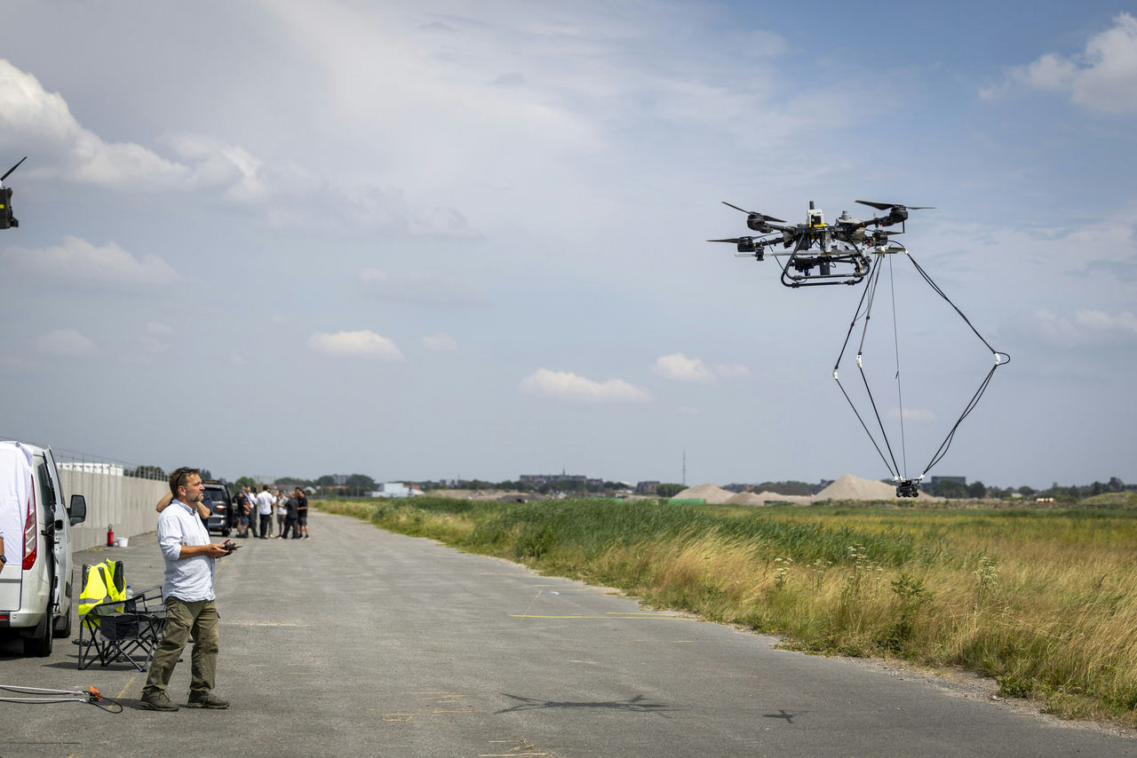
NATO-backed researchers have demonstrated autonomous aircraft and ground systems designed for tasks including search and rescue and unexploded ordnance detection, with several systems operating without satellite positioning, according to the organisation.
The demonstrations were held on 16 July at Unmanned Valley in the Netherlands as part of NATO’s Science for Peace and Security Programme, bringing together researchers, national representatives and Alliance specialists working on uncrewed and autonomous technologies.
According to a NATO, teams presented air and land systems intended for practical security applications, including search and rescue missions and demining operations.
One of the projects demonstrated was MINESEYE, formally titled Unexploded Ordnance Identification and Classification for Ukraine. The programme is examining how autonomous and uncrewed systems could assist with identifying and classifying unexploded ordnance, an issue of particular relevance in areas affected by sustained military operations.
The live demonstrations opened a two-day NATO workshop focused on uncrewed and autonomous systems. Researchers compared results from separate projects and discussed technical problems associated with autonomous decision-making, sensing, navigation and maintaining reliable operation in difficult environments.
Participants also examined vulnerabilities affecting such systems and areas in which separate research programmes could cooperate. The workshop forms part of NATO’s effort to bring together projects funded through the Science for Peace and Security Programme around common technical themes.
Alongside the demonstrations, NATO held the third SAPIENCE competition, which focuses on autonomous cooperation between multiple uncrewed aircraft.
Teams from City St George’s, University of London, the University of Klagenfurt in Austria, the University of Alabama in Huntsville and Delft University of Technology took part in the final round on 14 and 15 July. A team from City St George’s was named the winner of the competition.
The aircraft were required to operate through a simulated disaster area incorporating both indoor and outdoor environments. A central element of the challenge was completing the task without access to satellite positioning, requiring the aircraft to navigate using onboard systems and information shared between platforms.
Under the exercise scenario, the drones had to communicate with one another, allocate tasks autonomously and avoid obstacles, terrain and other aircraft without human correction. They were also required to interpret sensor information, locate simulated survivors and determine which supplies should be delivered according to the urgency of each case.
NATO said the combination of autonomous navigation, coordination and interpretation was intended to test whether the systems could progress beyond isolated experimental functions towards technology usable by emergency responders.
Removing reliance on satellite navigation presents a particular technical challenge for autonomous aircraft. GPS and other global navigation satellite systems are widely used to provide position and timing data, but military and emergency operations can take place in environments where those signals are unavailable, obstructed or subject to interference.




Not really a significant challenge, as we once managed to navigate without the use of GNSS (GPS) systems for at least 100 years. Particularly using radio navigation aids such as Tacan, Omega and Decca. Which in the day was “fairly” accurate, especially in the case of Tacan. Radio based navigation is pretty easy to set up, as you just need a minimum of three widely spaced transmitters, to use for triangulation. if you want to get a more bling system, you can replace the radio based transmitters with lasers. Which would also location accuracies measured in centimetres.
And of course, maps. More so for UAV’s where they can more clearly “see” the terrain in front of them. With Satellite technology where it is, it shouldn’t be too difficult maintaining up to-date charts. Especially when playing at home. i.e. Europe.
The beauty with Omega, was that it covered the whole globe. It was originally designed for US ballistic missiles subs. But was then used by military aircraft as a replacement for DECCA. Not sure if it was used by civilian aircraft?