The Royal Navy requires a LIDAR system capable of enhancing the situational awareness and collision avoidance of Uncrewed Surface Vessels.
The total budget for the purchase, including optional items, is £375,000.00. It is also noted that the system must be available for delivery prior to 20th March 2022.
According to a tender notice:
“Navy X requires an LIDAR system, capable of enhancing the situational awareness and collision avoidance of USV’s. Any candidate LIDAR needs to be open interfacing and have the ability to be integrated into existing navigational and anti-collision algorithms/behaviours.
The package should enhance the distance, accuracy or speed at which these behaviours can be executed. There should also be consideration for the relationship between data availability and the bandwidth between the ground control station and existing and future NavyX USV’s.”
All data should be processed onboard and have the ability tobe transmitted live, by line of sight and beyond line of sight communications. Also, the sensor system should have minimum range of 10m, hosted 2m above the water line.
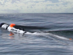
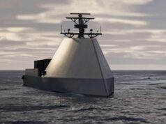
It is understood that the system will initially be housed on MADFOX, shown below.
What is LIDAR?
Lidar — Light Detection and Ranging — is a remote sensing method used to examine the surface of the Earth.





I was of the opinion this USV project was a joint endeavour with the French navy. So are they going for the same thing or is this just something extra the RN is after.
10m range? Is that a typo, must be 5+m to the bow?
It is a minimum range of 10 m.
Then a system with a range of 10m would comply. Seems rather short to be useful.
Well good luck to the company who propose a system with a minimum and maximum range of 10m. They will need it.
😄
“the sensor system should have minimum range of 10m”
Lidar great for looking down and producing amazing 3D topographical maps I take it that 10m from the bow range would entail extreme manoeuvrability by the Autonomous vessel? to avoid submerged hazards
If it’s placed 2m above the waterline I doubt it would be submerged objects it will be trying to avoid. I’d have thought the water’s surface, especially if a little choppy, would scatter a laser in ways too difficult create subsurface maps. My guess is it’s trying to avoid collision with other moving surface ships and boats.
Madfox is about 13m long. It looks from the photo like the deck is at least a metre above the surface. If we assume the mast is about 8m back, and the Lidar will be mounted on the mast 1m above the deck, the 10m minimum capability wouldn’t even reach the surface directly in front of the USV, much less underwater.
It would have to be mounted on the bow itself.
Perhaps Daniele can contribute here, but, was LIDAR not the super dooper solution railway level crossings and activated fail safe signals if movement detected.
The only problem is that blowing leaves, snow and other inclement weather could fail the system… great for safety not so great for operations. Just saying abd happy to be corrected by the grown ups.
Ha, over my pay grade David I’m afraid.
The railway already uses TPWS and AWS to stop trains. CCTV crossings rely on the Mk1 eyeball of the signaller before “Crossing Clear” and clearing signals.
The biggest issue with crossings is not finding a tech solution, but the cretins using them thinking it is fun to misuse them, ignore red lights, or climb over barriers. It is very irritating when we read of the likes of 2 girls with Walkmans on paying no indication to signs, not looking, and merrily strolling into the path of a train. Then the railway gets the blame! Nope.
Bit off topic but the RN are setting a pace with creative new technologies and ways of things.
https://www.royalnavy.mod.uk/news-and-latest-activity/features/think-differently
Could they not use the same technology found on I/R or laser guided missiles etc? Instead of homing in on a target steer away from it.
Sorry in advance if that sounds daft
We focus on Madfox (probably because it looks cool, although it is most likely viewed as an RM/SBS platform), but the Navy has recently bought one and ordered a second RS Aqua Otter Pro USVs, in addition to trialling a BAe USV add-on kit for the Pacific 24 RHIB. There are also Thales/Harris and Atlas Electronik USVs in service. https://rsaqua.co.uk/2021/06/otter-usv/
Otter Pro designed as a hydrographic survey tool, the BAe RHIB to provide interception and force protection for surface ships, Madfox for littoral strike / covert ISTAR and the AE and Thales vessels for MCM.